Below is a link to an ArcGIS online application know as "story maps". The application gives you an opportunity to present a project with an organized template which helps make maps more practical and readable for everyone else. This specific story map was an attempt to present an application that could be used when on the Nunckatessett Greenway Trail, located in Bridgewater and West Bridgewater Massachusetts. Although this story map isn't completely finished, something like this could be very useful when actually on the trail, these story maps can be accessed on mobile devices as well making very practical.
http://bsugis.maps.arcgis.com/apps/MapJournal/index.html?appid=1f5d3cf2f02c4e7f95e0f41be6f51dcc
Friday, May 13, 2016
Wednesday, March 30, 2016
Viewshed analysis
This map was created in ArcGIS online and uses the ArcScene application within the website. The map shows displays a viewshed analysis for the original Taunton Ma, courthouse. It displays a 20 mile radius of the visibility of the courthouse. The highlighted orange areas are points on the map where you can see the court house if you were on flat ground standing up based on a person with a 6 foot height.
Monday, March 28, 2016
Solar-Wind Village Proposal
This map was created in ArcGIS desktop version. It displays the potential locations for a Solar-Wind Village in the town of Adams, Massachusetts. The locations were found through a series of geo-processing steps to fit three main criteria for potential locations. These criteria consisted of having a slope of 20° or less, having a southerly aspect of 135°-225°, and wind speeds at 30 meters to be above 5 meters per second.


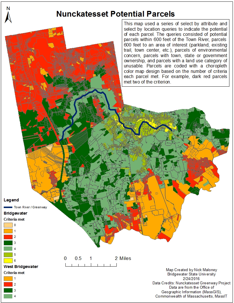
Wednesday, February 24, 2016
Nunckatesset Greenway project
Below is a map created in ArcMap desktop version. In this map making process a series of select by attribute and select by location queries were built to identify potential parcels for the Nunckatesset Greenway trail project.

Wednesday, February 17, 2016
Bristol, Plymouth, and Barnstable Counties
This map was created in ArcMap desktop version. It focuses on the population demographics of three South-East counties: Bristol, Plymouth, and Barnstable counties.


Mediterranean Cruise
Below is a map I created using ArcGIS online. It displays various ports I visited on a Mediterranean cruise in May 2015. Two of the most interesting places I stopped on the cruise were the ancient Vatican City and the ancient city of Pompeii. I also generated a QR code for a shortcut to the map, if you have a smart phone with a QR scanner give it a try.

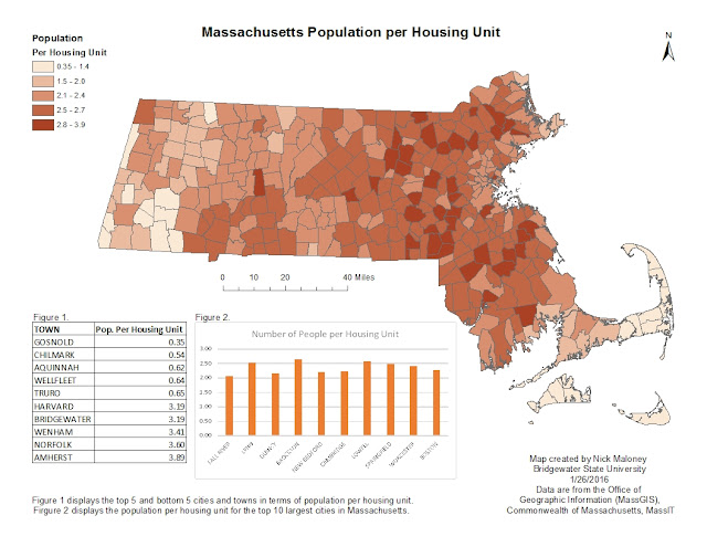
Wednesday, February 10, 2016
Massachusetts Population
Below is a map I made in ArcMap desktop version. It displays Population density for each town in Massachusetts using a choropleth map. The table to the lower right displays the top 5 and bottom 5 cities in terms of population. The bar graph the the lower right displays the top 10 most populated cities in Massachusetts.

Monday, February 8, 2016
UFO Sightings in the U.S.
Below is a brief map I made in ArcGIS online. It displays recorded UFO sightings in the United States. The data is from an excel file I extracted from Wikipedia.
Friday, January 29, 2016
Towns in Massachusetts Based on 2010 Population
Below is a Map of the 351 towns in Massachusetts. The map displayed is a choropleth map of the population for each town based on Population data from 2010.


Subscribe to:
Posts (Atom)